| May 6, 1999 |
|
Previous Next |
||
|
|
||||
|
| ||||
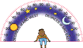 You would be surprised at what scientists use to make models! Many of you, by using your model made from a soda bottle, were able to copy the arc of the Sun across the sky by connecting the dots (your data points). But, we still need a way to communicate that information. Like other scientists, we describe our data in degrees of arc. Here's how:
| ||||
|
Mark the bottle at the places where it touches the N,E,S and W lines to help you line it up. Download this protractor image, print it out, and cut it out. You may want to paste it on a stiffer piece of cardboard. Tape a straw to the back, lift up an edge of your dome, and slide it in. The straw will stick through the opening of your plastic dome. Tape the dome down again over the center of the cross. The straw will let you rotate the protractor completely around inside the dome. | ||||
|
My friends Alison and Kevin told us that Sumerians first divided a circle into 360 parts (or degrees). A protractor is just half a circle, and it has half as many parts (this protractor also has 180, just add the 90on the left with 90 on the right). | ||||
|
Now, turn the protractor so that the marks along the curved edge line up with one of your dots. Write down the number of the mark. This is the height of the Sun (in degrees) from the horizon. | ||||
|
|
Take another set of measurements (write down the time and date for each dot). Compare them to your data from last week. What's the highest point (in degrees) each week? Is the Sun getting higher or lower? Now, take a look at the sunrise and sunset time for those days. Was the day longer or shorter? By how much? How does the arc of the Sun relate to the length of the day? Mail me what you find out or go to the Sun Spot on my Web site and enter it there. | |||
|
|
Watch (or tape) the Wayfinders: A Pacific Odyssey on KCET, May 6th at 10pm. This is about the Polynesians who, like their ancestors, use the Sun and stars to navigate across vast oceans. For thousands of years, people have taken measurements of the sky in order to locate their position on the Earth. Next week, we'll talk about this some more! | |||
| Whyville Square | Introduction | Series 1: Spinning | Series 2: About Time | Times Building Entrance | Log Out |